

Brussels (Brussels Morning Newspaper) September 13, 2026 – High temperatures and prolonged drought conditions have combined with historic land drainage practices to exacerbate wildfire risks in Belgium, following a major blaze that devastated 3,000 hectares of moorland in the High Fens nature reserve. Experts highlight that Belgium’s water-removal infrastructure, straightened rivers, and peatland degradation significantly hamper firefighting efforts, giving rise to persistent underground “zombie fires” and increasing exposure within the wildland-urban interface.
- Impact of the Devastating High Fens Wildfire on Local Communities
- Structural Infrastructure and Emergency Service Limitations in Belgium
- Soil Mechanics and the Underground Threat of Subterranean Zombie Fires
- Historical Forestry Practices and Environmental River Modifications
- Wildland-Urban Interface Hazards Facing Belgian Municipalities
- Potential Landscape Restoration Solutions to Mitigate Wildfire Hazards
Impact of the Devastating High Fens Wildfire on Local Communities
The aftermath of one of the largest wildfires in Belgian history continues to affect local communities approximately one month after flames broke out in the High Fens nature reserve. The fire, which swept through 3,000 hectares of protected moorland, highlighted severe landscape and infrastructural vulnerabilities in a nation historically unaccustomed to large-scale forest fires.
Academic experts and environmental researchers point out that the disaster was driven not merely by immediate summer heatwaves and dry spells, but by structural landscape modifications carried out across Belgium over centuries. According to Koenraad Van Meerbeek, an associate professor at KU Leuven, the natural resilience of the region has been heavily compromised by widespread soil drainage intended to support commercial forestry and agricultural activities.
Structural Infrastructure and Emergency Service Limitations in Belgium
Belgium’s prevailing damp climate and civil infrastructure have historically been engineered to shed water rapidly rather than retain moisture or mitigate fire hazards. Consequently, national emergency services and local authorities faced significant operational constraints when attempting to contain and extinguish the flames within the complex terrain of the High Fens nature reserve. Specialized, large-scale firefighting equipment and infrastructure, which are standard in Southern European nations where seasonal wildfires are frequent, are largely absent from Belgium’s national defence strategy.
Soil Mechanics and the Underground Threat of Subterranean Zombie Fires
The high susceptibility of the High Fens to extensive burning is directly linked to its soil composition. The reserve consists predominantly of peatland, an ecosystem naturally characterized by swampy conditions and dense vegetation. Extended periods of high temperatures and negligible rainfall dried out the naturally saturated organic layers, converting the peat into highly volatile fuel.
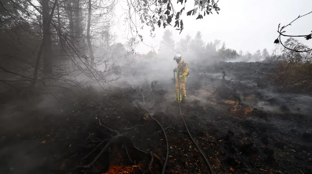
This condition creates a phenomenon known as “zombie fires,” wherein highly flammable organic soil continues to smoulder underground at low temperatures long after surface flames have been doused. These subterranean fires can traverse root systems and organic layers, unexpectedly reigniting surface vegetation days or weeks later. Emergency responders face severe technical difficulties in verifying whether an underground peat fire has been fully extinguished, requiring prolonged monitoring and resource deployment.
Historical Forestry Practices and Environmental River Modifications
In addition to climate factors, historical land management practices have exacerbated fire risks across the region. Large tracts of the High Fens and surrounding areas were modified for forestry, specifically for spruce plantations that require drier soil conditions. To accommodate these plantations, extensive drainage network systems were constructed to channel water away from the land.
Furthermore, civil engineering projects during the 19th and 20th centuries systematically straightened Belgian rivers and streams to streamline agricultural operations and prevent localized flooding. Naturally meandering river systems act as natural buffers by slowing water movement, raising the local water table, and keeping valleys and adjacent vegetation damp. The artificial straightening of these waterways accelerated runoff, effectively removing moisture from the wider ecosystem and lowering the landscape’s natural fire resistance.
Wildland-Urban Interface Hazards Facing Belgian Municipalities
Urban planning and settlement patterns have further heightened the risks associated with countryside fires. Researchers reference the concept of the “wildland-urban interface,” where residential structures and commercial developments directly abut or intermingle with undeveloped natural vegetation. In Belgium, this interface is evident around the High Fens, including municipalities such as Malmedy and Waimes, as well as residential zones and holiday accommodations situated near the Ardennes valleys, such as Achouffe and Viroinval.
The intermingling of built infrastructure with flammable natural vegetation creates operational challenges for emergency services during wildland fire incidents, as responders must simultaneously combat advancing fire fronts and execute structural protection or evacuation protocols for nearby communities.
Potential Landscape Restoration Solutions to Mitigate Wildfire Hazards
Addressing these systemic vulnerabilities will require long-term environmental and infrastructural interventions rather than immediate tactical adjustments. Environmental scientists emphasize that restoring natural waterway meanders, re-wetting degraded peatlands, and reducing forestry-related drainage are critical long-term measures required to bolster Belgium’s ecological resilience against future climate-driven wildfire events.